

If you’re looking for an Everglades National Park map to plan your next trip to the American National park, we can help.
Everglades national park is the largest subtropical wilderness in the United States with an average of one million tourists visiting every year. The unique treasure boasts incredible sights, fun activities, and is dominated by some of the most stunning fauna and flora in the world.
The Everglades is full of historical wetlands, and species of birds, reptiles, and mammals that visitors can explore in many ways. We provided a map to guide your visit to this park
Everglades National Park Map
The Everglades national park map shows the three entrances to the park which are located in different cities and hours away from each other.
The Ernest F. Coe Visitor Center in Homestead is the main entrance of the park. The shark valley is another entrance for visitors who want to observe the heart of the Everglades.
The last entrance is through the Gulf coast visitors center located south of Everglades city and close to Naples.
Each everglades national park entrance features its unique niche and can help choose where to enter during your trip planning.
The maps below highlight some of the points of interest in Everglades National Park to plan trips and enhance visiting experience.
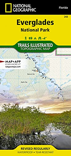
Consider a Detailed Topographic Map for Everglades
If you plan extensive hiking and backpacking in Everglades, I highly recommend getting a professional-grade topographic map from National Geographic.
Every Trails Illustrated map is printed on “Backcountry Tough” waterproof, tear-resistant paper. An entire UTM grid is published on the map to aid GPS navigation.
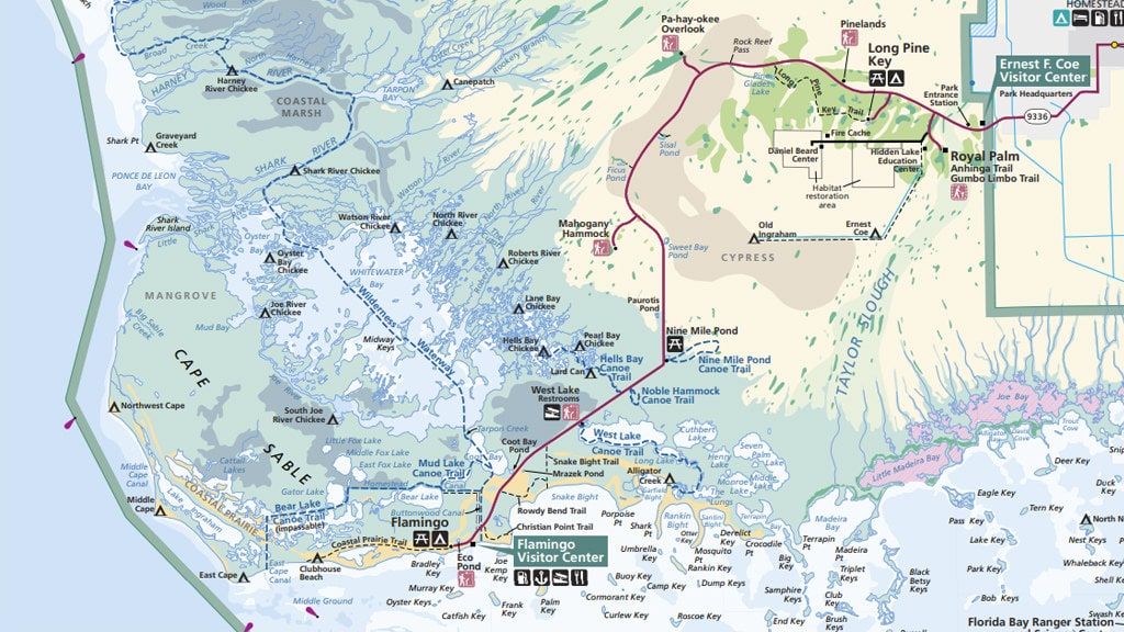
Everglades Flamingo Hiking Trails Map
This is a more detailed map showing the different hiking trails from the Flamingo Visitor Center.
From the map, the West lake trail is a self-guided boardwalk wandering through a forest of black mangrove, white mangrove, red mangrove, and buttonwood trees into the Westlake edges.
Snake bight trail, the name should not discourage you! The term ‘bight’ is only a portion of a bay (snake bight) in a large bay (the Florida bay). Visitors can hike through a hardwood hammock with many tropical tree species. A great bird watches on the boardwalk at the trail end for visitors who plan to arrive near high tide.
Take a bike ride through the Rowdy Bend Trail, the main park road, and the snake bight trail (carefully), which is about 12.7 miles. This is also an excellent place for woodland bird-watching.
The Christian point trail starts in mangroves and buttonwood with plenty of air plants and bromeliads.
Explore a dense hardwood hammock with mangroves on the Bear lake trail. This place accommodates over 50 different species of tree. The trail runs through the historic homestead canal, which is excellent for woodland birds.
The Guy Bradley Trails is where visitors can mingle with different birds and butterflies while ambling along the Florida Bay shores. Finally, explore the Eco Pond Trail with shorebirds, wading birds, and crocodiles. The old pier pilings indicate Flamingo’s history of being a small fishing village.

Everglades Flamingo Canoe Trails Map
This is a flamingo canoe trail map that shows the top canoe routes to camping opportunities.
Canoe trips can take anywhere from a few hours to a few days depending on the trail’s length and complexity.
Visitors can come with a canoe or a kayak or rent them at the park. On the other hand, permitted guides are always available to outfit the trips and guide the adventure.
Water levels in the Nine Mile ponds fluctuate significantly, so paddle across this area with care. Turn around if you encounter shallows.
Here, Periphyton, a large group of sponge-like organisms, can prevent smooth paddling. Do not proceed when there is an encounter with difficulty. If you have no idea of the route, don’t guess.
The Noble Hammock can be accessed from the main park road. The Trailhead winds through a maze of mangrove line creeks and ponds.
Hell’s bay winds through the mangrove ponds and creeks. The trail has over 160 poles.
Florida Bay offers an opportunity for fun activities such as fishing, watching bed feeds and millet jumps, or just enjoying the scenic bay. Open waters here are mosquito-free, even during summer.

Everglades Wilderness Campsite Map
Exploring a wilderness on water requires proper planning and preparation. Use this map as a guide to camping in the Everglades National Park.
Everglades national park features some of the largest wildness located east of the mountains.
Leave no trace: history claimed that visitors who passed through this area tried to leave no traces. The 7 leave no trace idea will help to fully take advantage of the wilderness experience.
- Prepare and plan
- Properly dispose of water
- Camp and travel on suitable surfaces
- Reduce campfire effects
- Leave whatever you find
- Consider other visitors
- Respect wildlife

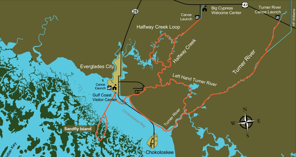
Everglades Gulf Coast Paddle Map
The Gulf coast paddle on the west coast of Florida can be accessed from Everglades City. There are also accessible private boat ramps in Chokoloskee and Everglades City.
Sandfly island loop is a padding trail accessible from the Gulf coast visitors center.
Turner river canoe launch 11.5 miles to the Gulf coast visitor center or 8.5miles to Chokoloskee. Keep in mind that this place may be impassable when the water levels are too low or too high. Also, there are alligators in this area.
Halfway Greek is not passable during this time. So it’s best to paddle towards the HC 1 marker from Big Cypress south.
But visitors can access the halfway Greek from the Gulf coast visitor center.
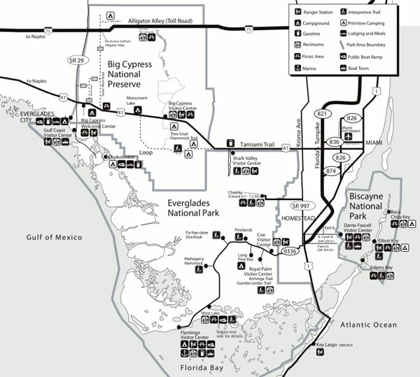
National Parks and Preserves of South Florida Map
This Map explores the national parks and preserves of south Florida.
The freshwater of the swamp in Big Cypress supports the neighboring Everglade’sEverglade’s health and the rich marine estuaries in the southwest coast of Florida. Dominating 729,000 acres of this swamp, Big Cypress national preserve is a mix of temperate and tropical plant communities with diverse wildlife like the endangered Florida panther.
Key Biscayne features a rare combo of emerald islands, aquamarine waters, and coral reefs. It also has evidence of thousands of human history: shipwrecks, presidents, and pineapple farmers. The park is known for diving, fishing, and boating destination.
Other parks here include Titusville, New Smyrna beach, key west, and the Fort Matanzas National Monument.
What is the Best Time to Visit Everglades National Park?
The best time to visit Everglades National Park is during the dry season. December through April offer consistent pleasant temperatures and low humidity with an average of five rainy days per month. The average temperature during these months is around 70 degrees, which is perfect for a day of hiking or canoeing.
The wet season runs from May to November when the weather is hot and humid.
Consider a Detailed Topographic Map for Everglades
If you plan extensive hiking and backpacking in Everglades, I highly recommend getting a professional-grade topographic map from National Geographic.
Every Trails Illustrated map is printed on “Backcountry Tough” waterproof, tear-resistant paper. An entire UTM grid is published on the map to aid GPS navigation.
Everglades National Park Map | Final Thoughts
The official Everglades National Park map is the most important map when planning your trip and exploring the park.
With Everglades National Park conserving over 1.5million acres of wetlands preserves with coastal mangrove, pine Flatwoods, and sawgrass marshes, there’s no better way to explore this wonderful park than through the guide of an official map.