As a park that encompasses over 1,500 square miles in Northern Montana close to the Canadian border, a Glacier National Park map is an essential part of planning your trip.
Glacier is one of the only places in the continental United States where you can see our planet’s endangered glaciers. The wild and vast nature of the park makes maps incredibly important in both planning and inspiration for your trip. Continue reading to find the Glacier National Park map for you.
Glacier National Park Map PDF (Official)
An all encompassing Glacier National Park map is an indispensable part of planning your trip to this beautiful park. The official Glacier National Park map is featured in the park brochure, which also includes Canada’s Waterton Lakes National Park which is across the border. The official map is the most important map when planning your trip and while exploring the park.
There is a lot more to this park than its glaciers! You’ll also see breathtaking scenery, and the first International Dark Sky Park to span an international border. Make sure to keep an eye out for the park’s wildlife which ranges from lynx and elk to grizzly bears and wolves. Not to mention, Glacier National Parks’ challenging treks, backcountry camping, scenic drives, and family-friendly hikes.
Consider a Detailed Topographic Map for Glacier
If you plan extensive hiking and backpacking in Glacier, I highly recommend getting a professional-grade topographic map from National Geographic.
Every Trails Illustrated map is printed on “Backcountry Tough” waterproof, tear-resistant paper. An entire UTM grid is published on the map to aid GPS navigation.
Glacier National Park Trail Maps
If you’re searching for a Glacier National Park map that covers all of the trails in the park, then look no further. With both mileage and elevation, as well as trailhead locations, this map makes finding the stunning trails of Glacier National Park easy. The National Park Service suggests that more than half of the visitors to Glacier National Park hike during their visit, making this map an important addition to your trip.
As you can see, hiking is an extremely popular activity during the summer, so arrive early to secure a parking spot ahead of the midday crowds. It’s a good idea to check the trail status report, and always pack bear spray and extra water when hiking in Glacier National Park.

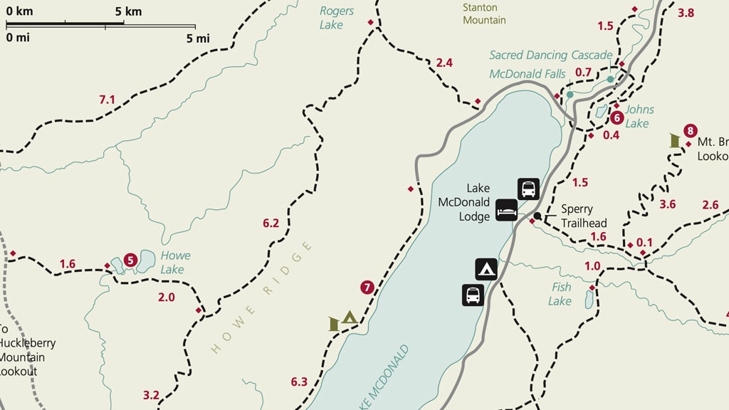
Glacier Lake McDonald Valley Trails Map
Lake McDonald Valley is an incredibly popular section of Glacier National Park. It is the hub of activity on the west side and features the largest lake in the park, Lake McDonald at a staggering 500 feet deep. This Glacier National Park map shows trails and points of interest such as the Apgar Visitor Center, and all along the shore of Lake McDonald.
The area features a visitor center, lodging options, restaurants, guided hiking and backpacking, and horseback riding.
Glacier Many Glacier Valley Trails Map
The Glacier Many Glacier Valley trail map zooms in on Many Glacier Valley and includes popular hiking trails starting near Swiftcurrent Lake such as the Grinnell Glacier trail. Apikuni Falls and the Grinnell Lake trail are other incredibly beautiful hikes in this portion of the park.
This area also offers several lodging options including the Many Glacier Campground, Many Glacier Hotel, and the Swiftcurrent Motor Inn.

Glacier St-Mary Valley Trails Map
If you’re looking for the famed Going To The Sun Road, then this Glacier National Park map is for you. Going-to-the-Sun Road is one of the top scenic drives in the United States called the “Crown of the Continent.” The eastern portion of Going To The Sun Road is in this area, but it’s important to keep in mind that this famed road is typically open from July – September each year due to snow.
Popular hikes in this area of the park include St. Mary’s Falls, Piegan Pass, and Red Eagle Lake.

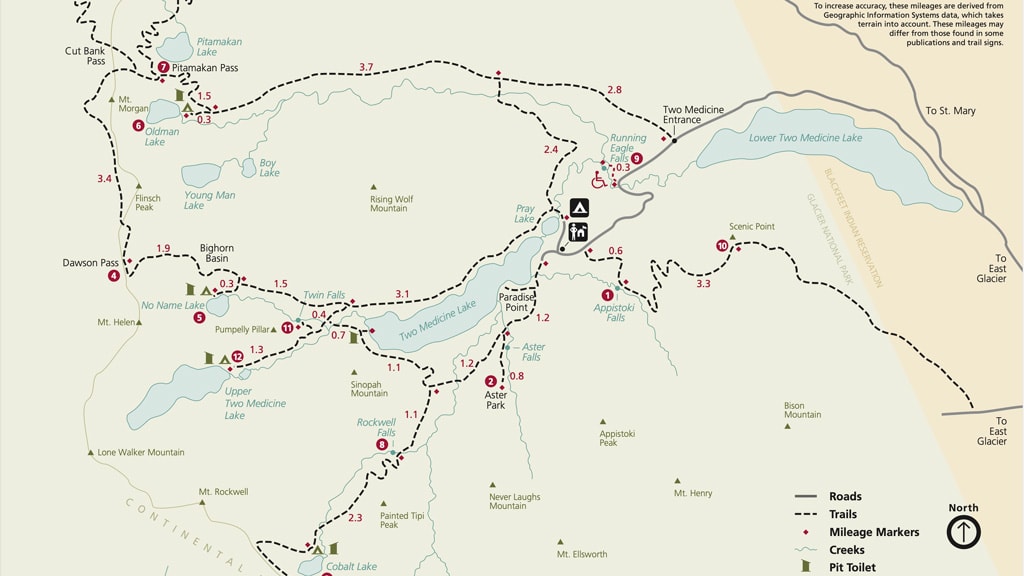
Glacier Two Medicine Valley Trails Map
The Glacier Two Medicine Valley trail map will give you a better idea of where to go in the least visited portion of the park. You’ll find plenty of lakes and waterfalls in this valley and incredible natural beauty. Popular hikes in this section of the park include Dawson Pass, Scenic Point, Twin Falls, and Upper Two Medicine Lake.
There is no lodging here, but there are a few backcountry camping sites to choose from in Two Medicine Valley.
Glacier National Park Campgrounds Map
Camping is one of the best ways to experience Glacier National Park. Camping beneath the big Montana sky is an experience you don’t want to miss.
This Glacier National Park Campground Map is a great tool to use to help you decide which campground is the right fit for you. There are an impressive number of campgrounds inside the park, and you can choose between first-come-first serve or reservation-based campgrounds.
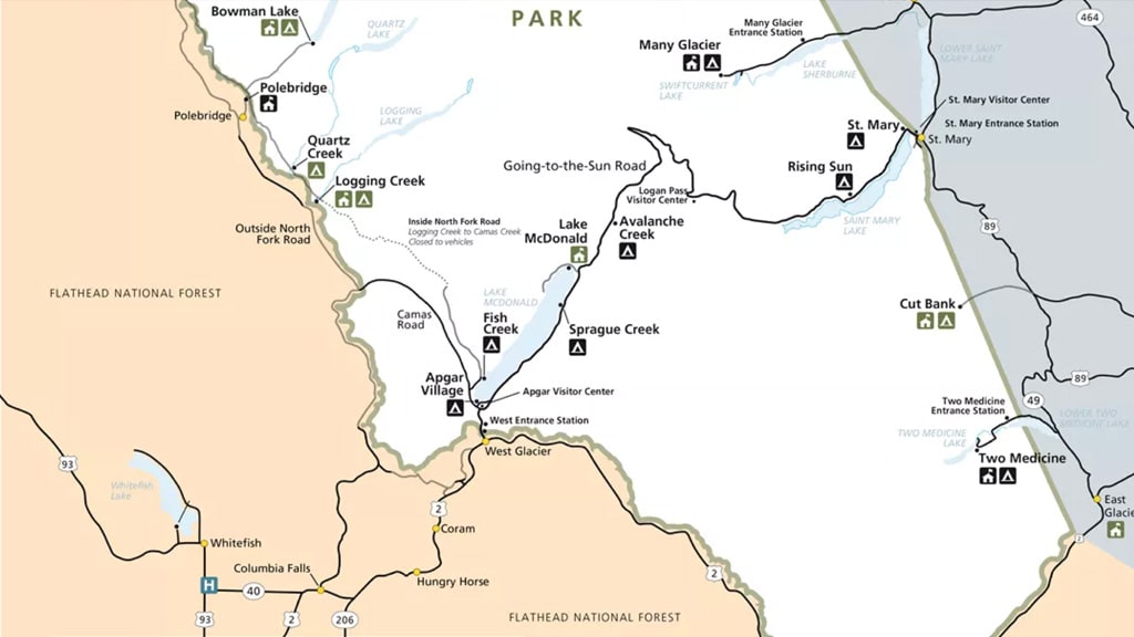
First Come First Serve Campgrounds In Glacier
- Avalanche Campground – just west of the Continental Divide
- Bowman Lake Campground – in North Fork
- Cut Bank Campground – east side of the park
- Kintla Lake Campground (most remote) – in North Fork
- Logging Creek Campground – south of Polebridge
- Quartz Creek Campground (smallest) – on North Fork Road
- Rising Sun Campground – west of St. Mary’s
- Two Medicine Campground – close to East Glacier
Reservation Campgrounds
- Apgar Campground (largest) – near Lake McDonald
- Fish Creek Campground (second largest) – near West Glacier
- Many Glacier Campground – in the Many Glaciers area
- St. Mary’s Campground – in the St. Mary’s area
- Sprague Creek Campground – northeast shore of Lake McDonald
Glacier Going-to-the-Sun Road Terrain Map
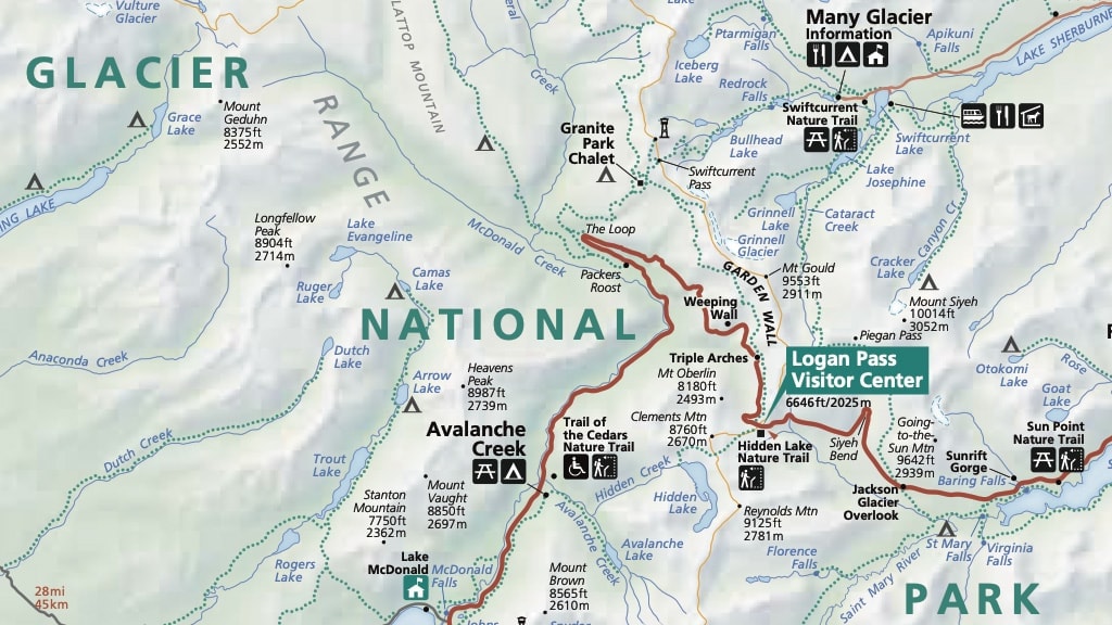
Going-to-the-sun Road is one of the biggest attractions in Glacier National Park. This famous road known as the ‘Crown Of The Continent’ takes approximately 2 hours to drive, at a full 50 miles in length, it’s impressive! The Glacier Going-to-the-Sun Road terrain map is a great way to scout out where you want to stop along this famous scenic drive.
Logan Pass is the highest point on Going-to-the-Sun Road at a staggering 6,646 feet. Keep in mind that the speed limit is 40 mph at the lower elevations of the road and 25 mph on the alpine section.
It’s also a good idea to plan ahead if Going-to-the-Sun road is high on your Glacier National Park list. The lower elevation sections of the road remain open year-round and provide access to many activities. However, the summer opening date of the alpine portion varies from year to year, based on snowfall and plowing progress. There is no set date for the road to open over Logan Pass. However, the road is typically fully opened by July.

Glacier Vegetation Park Map
The Glacier Vegetation Park map provides an overview of the vegetation layers in the park. It gives you some interesting insight into the geological wonders to behold at Glacier National Park. It also includes Waterton Lakes National Park across the Canadian border. This map shows the types of grasslands, forests, meadows, and other vegetation.

What is the Best Time to Visit Glacier National Park?
The best time to visit Glacier National Park generally depends on what you are interested in doing inside the park. For the most part, summer is the best time to visit the park because Going-to-the-Sun Road tends to be open during the summer and holds some of Glacier’s most stunning views. Summer season in Glacier is typically from late June to mid-September.
Consider a Detailed Topographic Map for Glacier
If you plan extensive hiking and backpacking in Glacier, I highly recommend getting a professional-grade topographic map from National Geographic.
Every Trails Illustrated map is printed on “Backcountry Tough” waterproof, tear-resistant paper. An entire UTM grid is published on the map to aid GPS navigation.
Glacier National Park Map | Final Thoughts
Glacier National Park in Montana is one of the most scenically beautiful parks in the United States. Due to its large size and the remote nature of some parts of the park, planning your trip there can feel a bit overwhelming. Using these Glacier National Park maps is a great way to start the planning process and they will make a great addition to your trip once you are in the park.
Glacier National Park has it all – camping, hiking, scenic drives, and wildlife. This park has something amazing waiting for you!


