

Although it’s one of the smaller parks in Utah, at just 229 square miles, using a Zion National Park Map will help you to plan your visit. The park’s awe-inspiring photogenic scenery makes it one of the most beloved National Parks in the United States. Famous for the reddish hue of its cliffs, Zion is ruggedly and spectacularly beautiful. Use Zion National Park maps to plan the perfect visit to this spectacular park.
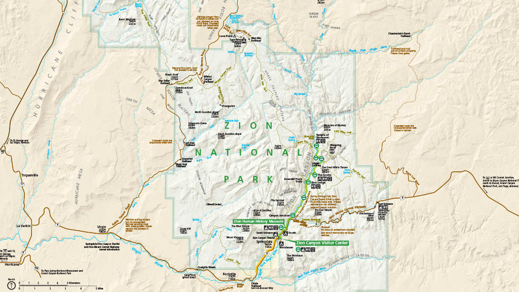
Zion National Park Map PDF (Official)
Zion is the second most visited park in the United States, making it challenging to avoid the crowds at the park. There is no shortage of amazing things to see and do at Zion. Use the official Zion National Park map to plan your trip.
Download the Official Zion National Park Map PDF (0.5 MB)

Consider a Detailed Topographic Map for Zion
If you plan extensive hiking and backpacking in Zion, I highly recommend getting a professional-grade topographic map from National Geographic.
Every Trails Illustrated map is printed on “Backcountry Tough” waterproof, tear-resistant paper. An entire UTM grid is published on the map to aid GPS navigation.
The beautiful, diverse landscapes and the fantastic hiking opportunities draw the crowds to Zion National Park. In fact, the park has some of the most popular hiking trails in the nation, including the Subway, the Narrows, and of course, Angels Landing. Of course, adventure lovers can’t get enough of this hiking mecca, but you can also climb, backpack, camp, and do some canyoneering while visiting Zion.
Thanks to its location in southwest Utah, it’s an easy drive from several metropolitan areas, including Las Angeles and Las Vegas. In fact, one of the most popular ways to get to the park is on a one-day bus trip from Las Vegas.
For most of the year, from mid-February through November, driving your personal car is not permitted in the most popular area of the park, Zion Canyon. Instead, Zion National Park uses a free shuttle system to reduce traffic congestion. The shuttle service begins at the visitor center and extends to the end of Zion Canyon Scenic Drive at the Temple of Sinawava. It stops at all major trailheads and runs every 10-15 minutes, and it is an incredibly simple way to get around the park.
Beginning around mid-morning, the lines for the Zion Shuttle can be incredibly long, leading to an hour or more wait times. It’s a good idea to plan to get there early and be on one of the first few shuttles of the day.
Zion National Park Regional Map
Located in Southern Utah, Zion National Park is only accessible by car. The park lies East of Interstate 15 and has 3 entrances, including
- Northwest Entrance – is east of Interstate 15.
- East Entrance – accessible from Utah State Route 9 and is closed during the winter months.
- South Entrance – also located on Utah State Route 9 at the exit of the town of Springdale. The South Entrance is the most visited park entrance at Zion.
Entrance fees and passes are required to enter Zion National Park.
Download the Zion National Park Regional Map PDF (0.6 MB)

Zion National Park Canyon Map
Zion Canyon is the most popular park area, making the Zion National Park Canyon Map essential to planning your visit. In addition, this area features two of the most popular hikes in the park, Angels Landing and the Narrows.
Starting in 2022, Zion now requires a permit to hike Angels Landing. The system was implemented to control the number of people on the trail and preserve the trail. Permits are awarded by a lottery system, both seasonally and the day before your hike. It costs $6 to submit an application, and if you are lucky enough to win, you will pay $3 per person to hike the trail.
While hiking the Narrows, you are hiking in the North Fork of the Virgin River through a beautiful slot canyon. Remember that during periods of high water flow, the Narrows trail closes. This happens most often from mid-March to mid-May.
If you want to access Zion Canyon by car, you’ll need to stay at the Zion Lodge. Otherwise, Zion Canyon is only accessible by using the shuttle service. To avoid crowds, getting to the shuttle first thing in the morning is best. Although that may require an early wake-up, after 9 am, it’s challenging to get to the shuttle, and you will be waiting for an hour or more.
Download the Zion Canyon Detailed Map PDF (0.7 MB)

Zion National Park Hiking Maps
Zion National Park is a hiker’s paradise, and this Zion hiking map can help you decide which hikes are suitable for you. The maps include difficulty ratings, distance, and a short description of each hike. The park carries a reputation as a bucket list hiking destination for adventurous trail seekers around the world.
Beyond the popular trails Angels Landing and the Narrows, many of Zion’s trails are excellent. Some of the most popular trails in Zion National Park are
- Emerald Pools Trail – 1.5 to 3 miles, stunning scenery
- Zion Canyon Overlook Trail – 1 mile, amazing views
- The Watchman – 3.3 miles, short and easy trail
- The Subway – 10 miles, gorgeous slot canyon
- Observation Point – 8 miles, classic Zion view
Download the Zion National Park Hiking Map PDF (2.8 MB)

Zion National Park Camping Maps
There are 2 well-equipped campgrounds within the park, Zion South Campground, and Zion Watchman Campground, near the South Entrance. To camp at Zion, you must make reservations well in advance. It isn’t easy to get reservations at either of the 2 fully equipped campgrounds; however, they are not your only option.
Zion National Park also has one free campground, the Lava Point Campground. There are also many backcountry camping sites. You will need to get a permit at the Visitor Center to camp at any backcountry sites. You can obtain a permit 3 months before your trip. They are primitive, and you’ll need to be prepared and well-equipped for this camping trip.
Keep in mind that the park is a desert-like environment. There are very few trees to provide relief from the heat in the campground. While some campsites get shade for part of the day, many get no shade.
Zion South Campground
The Zion South Campground offers 117 campsites with restroom facilities and potable drinking water. This campground closes during the winter months. You can make reservations for the South Campground on a 14-day rolling basis. Tent-only campsites are around $20 per night.
Download the Zion South Campground Map PDF (0.2 MB)

Zion Watchman Campground
The Zion Watchman Campground features 190 campsites, restroom facilities, and potable drinking water. It’s open year-round, and you can make reservations 6 months in advance.
Reservations are necessary here because the campground stays at capacity during peak season. Watchman is the most popular campground in the park because it’s closer to Springdale. You can easily walk to Springdale to shop or grab a burger and a beer. A standard tent-only campsite is around $20 per night.
Download the Zion Watchman Campground Map PDF (0.4 MB)

Zion Lava Point Campground
The Lava Point Campground is free and does not take reservations. The campground is open from May through September. This small campground offers 7 campsites and is located at a higher elevation than the other camping options in the park.
Download the Zion Lava Point Campground Map PDF (0.1 MB)
Lava Point is about a one-hour drive from Springdale, and you’ll take Kolob Terrace Road. This is my favorite place to camp during the hot summer months. Thanks to the elevation, it tends to stay cooler at Lava Point.
Zion Narrows Campsites
The Narrows Campsites are part of the backcountry camping experience at Zion National Park. Camping here requires a permit you can get at the Visitor Center. The campsites are assigned during the permit process, and when staying here, you’ll need to watch for flash floods.
Download the Zion Narrows Campsites Map PDF (2.4 MB)

Zion Southwest Desert Campsites
The Southwest Desert Campsites are also part of the backcountry camping system at Zion. Camping at these sites does require a permit that you can easily get at the Visitor Center when entering the park. You will be assigned a campsite while getting your permit.
Download the Zion Southwest Desert Campsites Map PDF (1.4 MB)

Zion National Park Wilderness Map
The best way to fully immerse yourself and appreciate Zion is to avoid the crowds and explore the park’s backcountry areas. You can use this Zion National Park wilderness map to plan your venture into the backcountry.
Even during the busy summer months, you won’t see many people in the backcountry at Zion National Park. Keep in mind that if you plan on backcountry camping, you will need to get a permit from the Visitor Center.
When exploring the backcountry of Zion, please remember to practice Leave No Trace, respect the wildlife, and that campfires are not permitted.
Download the Zion National Park Wilderness Map PDF (1.4 MB)

Consider a Detailed Topographic Map for Zion
If you plan extensive hiking and backpacking in Zion, I highly recommend getting a professional-grade topographic map from National Geographic.
Every Trails Illustrated map is printed on “Backcountry Tough” waterproof, tear-resistant paper. An entire UTM grid is published on the map to aid GPS navigation.
What is the Best Time to Visit Zion National Park?
Deciding when to visit Zion National Park can be a bit of a challenge. Summers are sweltering, and winters are cold. However, the park is always busy, so planning does require some strategy.
One of the best time to visit Zion is during the fall, and you’ll experience the maples and cottonwoods turning their beautiful fall colors. The weather is at its mildest, and you’ll avoid both the heat and crowds of summer.
Zion National Park Map | Final Thoughts
These Zion National Park maps will help you plan the best way to explore this adventure lover’s paradise. As one of the most beloved National Parks in the United States, Zion will leave a lasting impression on you.